SOCKS

An online magazine of Art, Architecture, Media, Culture, Sounds, Territories, Technology)

  • Media
  • Art
  • Architecture
  • Culture
  • Sounds
  • Territories
  • Visual Atlas

Dymaxion map, by Michael Paukner

May 8, 2011 by Fosco Lucarelli Leave a Comment

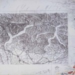
We’ll come back to the great illustrations of Michael Paukner, but for the moment, here’s his free printable cut-out sheet version of Bucky Fuller‘s Dymaxion map of the Earth.

“The Dymaxion map or Fuller map is a projection of a World map onto the surface of a polyhedron, which can then be unfolded to a net in many different ways and flattened to form a two-dimensional map which retains most of the relative proportional integrity of the globe map. It was created by Buckminster Fuller, who claimed that his map had several advantages over other projections for world maps. It has less distortion of relative size of areas, most notably when compared to the Mercator projection; and less distortion of shapes of areas, notably when compared to the Gall-Peters projection. Other compromise projections attempt a similar trade-off.

More unusually, the Dymaxion map does not have any “right way up”. Fuller argued frequently that in the universe there is no “up” and “down”, or “north” and “south”: only “in” and “out”. Gravitational forces of the stars and planets created “in”, meaning ‘towards the gravitational center’, and “out”, meaning “away from the gravitational center”. He attributed the north-up-superior/south-down-inferior presentation of most other world maps to cultural bias.”

Full text on: en.wikipedia.org/wiki/Dymaxion_map_of_the_Earth.

Click on the image to download the pdf cut-out:

Related Posts

  • Unreal Estates of China, by Map Office

    MAP OFFICE (Gutierrez, Portefaix) recently published a book titled Unreal Estates of China, with 56…

  • Manufacturing Nature: "Trees by Man" by Michael Amery

    Michael Amery is an artist based in Cape Town, South Africa with a graphic design…

  • LIVE FOREVER - The Michael Jackson Monument Design Competition

    Intelligent, critical, to the point. LIVE FOREVER - The Michael Jackson Monument Design Competition  

  • The Map as an Artistic Territory: Relief Shading Works and Studies by Eduard Imhof

    Eduard Imhof (1895 - 1986) was a professor of cartography at the Swiss Federal Institute of Technology,…

  • Michael Webb interviewed by Tim Abrahams

    On drawing techniques, Sin Centre, new and old technologies, America and the golden years. Tim…

Leave a Reply

Your email address will not be published. Required fields are marked *

  • Instagram
  • Twitter
  • Facebook
  • Tumblr

Socks is a non-linear journey through distant territories of human imagination.

About | Visual Atlas | Topics

We are Mariabruna Fabrizi and Fosco Lucarelli from Microcities. Ask us anything

  • Instagram
  • Twitter
  • Facebook
  • Tumblr


SOCKS is a project by Fosco Lucarelli and Mariabruna Fabrizi of MICROCITIES, Architecture Cityscape, Landscape.
Except where otherwise noted, the content on this site is licensed under a Creative Commons Attribution-ShareAlike 3.0 license.
Whenever possible we try to attribute content (images, videos, and quotes) to their creators and original sources. Please feel free to write us if you notice misattributions or wish something to be removed.
SOCKS is powered by WordPress.