SOCKS

An online magazine of Art, Architecture, Media, Culture, Sounds, Territories, Technology)

  • Media
  • Art
  • Architecture
  • Culture
  • Sounds
  • Territories
  • Visual Atlas

The Territory as an Abstract Cartography

October 10, 2012 by Fosco Lucarelli 1 Comment

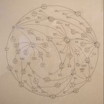
Waiting to find some time to write a more extensive post, we leave you with the marvelous details of early geological maps from the 19th and 20th century.
The absence of any visual or territorial reference gives to these maps the character of early abstract expressionist paintings.

Thanks to the guys of Gallica.

Carte géologique de la France, 1906

Carte géologique du massif de la Sainte-Baume, 1922

Carte géologique des Pyrénées de l’Aragon / par Marius Dalloni, 1910

Carte géologique du Rouergue et de la Montagne-Noire / par Jules Bergeron, 1888

Geologische Karte von Central Europa… (Dritte Auflage) / von Heinrich Bach, 1859

Carte géologique du département de la Haute-Marne exécutée sous les auspices du Conseil Général, 1859-1865

Carte géologique de Seine-et-Oise, 1923

Carte géologique de la Manche, 1923

Carta geologica del Friuli, 1881

Geologische Karte von Oesterreich-Ungarn, 19e siècle

Geognostische Übersichtskarte des Harzgebirges, 19e siècle

Mapa geológico de España y Portugal, 1879

Related Posts

  • Arabic Machines: Early Schematics

    Water powered systems, pulleys and gearing mechanisms, images from an arabic manuscript, datable from the…

  • Makihiko, by Roberto la Forgia

    "Insomma cercate di capire: sono a casa dei miei genitori e la voglia di non…

  • Grant Wood and Regionalism (Visions on Rural Life and Work)

    Together with John Steuart Curry and Thomas Hart Benton, Grant Wood was one of the…

  • Mark Lombardi's Narrative Structures and Other Mappings of Power Relations

    (...) the great question today is the question of globalization, the question of the unity…

  • Olympic Diving Diagrams, from the Stockholm games of 1912

    Right after the end of this year Olympic games in London, a little divertissement from…

Trackbacks

  1. Whewell’s Gazette: Year 3, Vol. #04 | Whewell's Ghost says:
    September 21, 2016 at 5:22 pm

    […] SOCKS: The Territory as an Abstract Cartography […]

Leave a Reply

Your email address will not be published. Required fields are marked *

  • Instagram
  • Twitter
  • Facebook
  • Tumblr

Socks is a non-linear journey through distant territories of human imagination.

About | Visual Atlas | Topics

We are Mariabruna Fabrizi and Fosco Lucarelli from Microcities. Ask us anything

  • Instagram
  • Twitter
  • Facebook
  • Tumblr


SOCKS is a project by Fosco Lucarelli and Mariabruna Fabrizi of MICROCITIES, Architecture Cityscape, Landscape.
Except where otherwise noted, the content on this site is licensed under a Creative Commons Attribution-ShareAlike 3.0 license.
Whenever possible we try to attribute content (images, videos, and quotes) to their creators and original sources. Please feel free to write us if you notice misattributions or wish something to be removed.
SOCKS is powered by WordPress.