SOCKS

An online magazine of Art, Architecture, Media, Culture, Sounds, Territories, Technology)

  • Media
  • Art
  • Architecture
  • Culture
  • Sounds
  • Territories
  • Visual Atlas

When the Earth Began Looking at Itself: the Landsat Program

July 22, 2013 by Fosco Lucarelli 3 Comments

When the first images were transmitted from the Landsat 1, only days after the small unmanned satellite was launched in 1972, cartography and Earth sciences were changed forever.

Although a civilian terrestrial remote-sensing satellite was proposed in 1965, it was only in 1970, after hard political struggle, that NASA was given the funding for an Earth Resources Technology Satellite (ERTS). The satellite itself, later renamed Landsat (in 1976), was designed, built and launched in only two years.

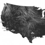
Not only  Landsat images were used to correct previous geographic and topographic maps (which instantly appeared out of date), but they started being considered maps in themselves, and mosaics of cloud free areas were substantially useful for geologists, hydrologists, oceanographers, agronomists, the military and even for public purposes, as for the iconic 10 × 16 foot map (about 300 x 490 cm) of the United States, composed of 700 mosaics, prepared in time for the National Geographic US Bicentennial.

The Landsat program still generates more 400 images a day through the still orbiting units 5 and 7, equipped with a technology that has been improved over the years, to produce even more detailed maps. A nearly real-time video feed of Landsat 5 or 7 is visible here.

Informations and images via Codex99.

Related: Satellite Imagery.


landsat-01-prairie_sm

Minnesota, the UP, Wisconsin, Illinois and Iowa.


landsat-02-dallas_lg

Dallas (I–14) – Ft. Worth. 25 Jul 1972


landsat-03-everest_lg

India-Nepal. Mt. Everest is located at T–1. 14 Dec 1972.


landsat-04-grand_canyon_lg

The Grand Canyon, 3 May 1973. 


landsat-05-monterey_lg

Geology of Central California. 1972


landsat-06-wyoming_lg

Wyoming Mosaic, 1972.


landsat-07-iran_lg

Southern Iran.


landsat-08-us_1974_lg

NASA 74-H-275


landsat-09-rossi_lg

Tony Rossi working on the original map.


landsat-10-us_1976_lg

Portrait U.S.A., 1976


landsat-11-atlas_lg


The Conterminous United States. National Atlas


All images, except the US ones, are from: Short, Nicholas, Lowman, Paul, et. al. Mission To Earth: Landsat Views the World.Washington, D.C.; NASA, 1976 (NASA SP–360). This oversized “coffee-table” book included 400 plates, which are online at the NASA Astrophysics Data System.


Related Posts

  • Steampunk looking but actually old Harmonic Synthesizer

    The Harmonic Synthesizer is an the lobby of the McLennan physics building, University of Toronto.…

  • Mapping the flowing of wind

    Wind Map live-traces the flowing of wind across the territory of the United States. This…

  • Comparing Urbanization

    Berkeley's  Global Metropolitan Observatory is a site focusing on large trasformation of cities. Using aerial…

  • Irene (August 26th, 2011)

    Tom Waits: Goodnight Irene Click for original 3072x3072px size on Nasa Goddard flickr.

  • NASA's 1976 identity guidelines

    Four pages of an original copy of NASA’s identity guidelines, from when they re-branded to…

Comments

  1. Test says

    September 16, 2016 at 11:54 pm

    We absolutely love your blog and find many of your post’s
    to be what precisely I’m looking for. can you offer guest writers to
    write content to suit your needs? I wouldn’t mind creating a post or
    elaborating on many of the subjects you write with regards to here.
    Again, awesome website!

  2. fosco lucarelli says

    October 19, 2016 at 7:07 pm

    Thanks, but we don’t need guest posting.
    FL

Trackbacks

  1. Celebrating a 40 year milestone of Landsat Color photomosaics says:
    July 18, 2016 at 6:48 pm

    […] the blog post, “When the Earth Began Looking at Itself: the Landsat Program,” Fosco Lucarelli, provides additional history and images of Landsat program. The PORTRAIT U.S.A is […]

Leave a Reply

Your email address will not be published. Required fields are marked *

  • Instagram
  • Twitter
  • Facebook
  • Tumblr

Socks is a non-linear journey through distant territories of human imagination.

About | Visual Atlas | Topics

We are Mariabruna Fabrizi and Fosco Lucarelli from Microcities. Ask us anything

  • Instagram
  • Twitter
  • Facebook
  • Tumblr


SOCKS is a project by Fosco Lucarelli and Mariabruna Fabrizi of MICROCITIES, Architecture Cityscape, Landscape.
Except where otherwise noted, the content on this site is licensed under a Creative Commons Attribution-ShareAlike 3.0 license.
Whenever possible we try to attribute content (images, videos, and quotes) to their creators and original sources. Please feel free to write us if you notice misattributions or wish something to be removed.
SOCKS is powered by WordPress.