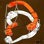
We’ll come back to the great illustrations of Michael Paukner, but for the moment, here’s his free printable cut-out sheet version of Bucky Fuller‘s Dymaxion map of the Earth.
“The Dymaxion map or Fuller map is a projection of a World map onto the surface of a polyhedron, which can then be unfolded to a net in many different ways and flattened to form a two-dimensional map which retains most of the relative proportional integrity of the globe map. It was created by Buckminster Fuller, who claimed that his map had several advantages over other projections for world maps. It has less distortion of relative size of areas, most notably when compared to the Mercator projection; and less distortion of shapes of areas, notably when compared to the Gall-Peters projection. Other compromise projections attempt a similar trade-off.
More unusually, the Dymaxion map does not have any “right way up”. Fuller argued frequently that in the universe there is no “up” and “down”, or “north” and “south”: only “in” and “out”. Gravitational forces of the stars and planets created “in”, meaning ‘towards the gravitational center’, and “out”, meaning “away from the gravitational center”. He attributed the north-up-superior/south-down-inferior presentation of most other world maps to cultural bias.”
Full text on: en.wikipedia.org/wiki/Dymaxion_map_of_the_Earth.
Click on the image to download the pdf cut-out:


Leave a Reply