SOCKS

An online magazine of Art, Architecture, Media, Culture, Sounds, Territories, Technology)

  • Media
  • Art
  • Architecture
  • Culture
  • Sounds
  • Territories
  • Visual Atlas

Stephen Walter’s Maps

May 27, 2012 by Fosco Lucarelli Leave a Comment

Stephen Walter‘s maps are the result of an intersection of signs and symbols. In Walter’s practice, objects tend to be replaced by their representation, evolving into intricate geographies of both real places and fictitious lands.

So far his work has explored the city of Liverpool, London (“The island”), and also London’s underground.

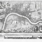
“Britain is a collection of islands and it undoubtedly forms part of our identity. This provincialism; the centre of many industries and in particular the London Centric Art world and its rise again to a world city status add to its identity as an icon, separated from the rest of the country. I wanted to perceive London as another one of these ‘islands’, and so when mapping the coastline around its Borough edges I was happy to discover Carshalton Beaches coinciding with this border.”

“The resulting map, a spoof of the historical ones of old, would challenge the first impressions of its viewer; touching on the Capital’s vastness, its secrets and its undercurrents. With this process in mind, I began to edit the information, keeping what I felt were historically important, interesting, relevant and amusing. These fantastical additions and epithets are purposefully innocent and acidic, trivial and serious. The Map is as much about the personality of its viewer than it is about of my own. In other words it acts as a mirror.”

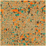
Map of Liverpool 2008-09

The island (Map of London and its neighborhoods / details)

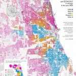
In the Map of Subterranean London, Walter looked for buried rivers, Tube lines, tunnels, bunkers, sewers along with unsolved secrets, murders and mysteries of the hidden side of the town.
Via: Londonist

Map of Subterranean London

Related Posts

  • 250mb of old maps of South London

    Maps dating back to the 16th century, free for downloading. Here. Londini Angliae Regni Metropolis…

  • City Maps by Jazzberry Blue

      Jazzberry Blue is an an artist and illustrator based in Toronto. Among his rich…

  • Taxonomies of Transition: Urban Segregation Maps by Bill Rankin and Eric Fisher

    "A taxonomy of transition", (2009) by radical cartographer Bill Rankin is a visual essay on…

  • XVII Century Processions

    From Christie's: THE PROCESSION OF THE GUILDS AND THE PROCESSION OF NOTRE-DAME DU SABLON DURING…

  • Venice Art Biennale 2011 quick round-up

    Just came back from Venice 2011 Art Biennale. Obviously, as everybody said, a Gesamtkunstwerk paradise,…

Leave a Reply

Your email address will not be published. Required fields are marked *

  • Instagram
  • Twitter
  • Facebook
  • Tumblr

Socks is a non-linear journey through distant territories of human imagination.

About | Visual Atlas | Topics

We are Mariabruna Fabrizi and Fosco Lucarelli from Microcities. Ask us anything

  • Instagram
  • Twitter
  • Facebook
  • Tumblr


SOCKS is a project by Fosco Lucarelli and Mariabruna Fabrizi of MICROCITIES, Architecture Cityscape, Landscape.
Except where otherwise noted, the content on this site is licensed under a Creative Commons Attribution-ShareAlike 3.0 license.
Whenever possible we try to attribute content (images, videos, and quotes) to their creators and original sources. Please feel free to write us if you notice misattributions or wish something to be removed.
SOCKS is powered by WordPress.