A pole of inaccessibility is an extreme point of Earth which is hard to reach due to its remoteness to geographical features that could provide access.
Standing among those places that have traditionally titillated the dreams of the explorers, they have become easily reachable, today, through the improved technology of drones and satellites, providing a last resort of linkage even in those cases in which urbanization or infrastructural connections are still absent.
The improvement in technology is also responsible of the on-going refinement of the exact geographical coordinates, in some cases providing a variety of different locations. Particularly, in the case of the Northern and Southern poles, discrepancies are produced by the way the coast is measured to the grounding line or to the edges of ice shelves, by the movement of ice sheets and by the unreliability of past survey data.
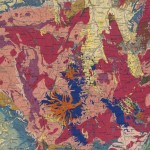
Here’s a Mollweide projection map showing: distance to the nearest coastlines, red spots of inaccessibility, isolines every 250km, thick lines every 1000km.

Of course the two most notable poles of inaccessibility are the Southern and Northern poles (read more on the Antarctic research station).
Apart from these locations, other extremely hard-to-reach places on earth are the following:
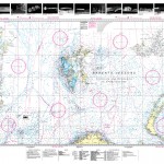
The Oceanic pole of inaccessibility: the place on the waters which is farthest from the land (48°52.6′S 123°23.6′W), which lies in the South Pacific Ocean, 2,688 kilometres (1,670 mi) from the nearest lands. This location is also referred to as “Point Nemo”, a reference to Jules Verne‘s Captain Nemo. On Google Earth, a circle with the text “NEMO” printed next to it, slightly darkened on the actual map itself, can be seen at this point.
The Continental Pole of Inaccessibility, correspond, in Eurasia, to the place on land which is farthest from the ocean (46°17′N 86°40′E), and that lies in north-western China, near the Kazakhstan border, at about 2,645 km (1,644 mi) from the nearest coastline.
In North America, the CPI is in southwest South Dakota about eleven miles southeast of the town of Kyle, located 1,650 km (1,030 mi) from the nearest coastline at 43.36°N 101.97°W.
In South America, the CPI is in Brazil at 14.05°S 56.85°W, near Arenápolis.
In Australia, the CPI is located either at 23.17°S 132.27°E or at 23°2′S 132°10′E, 920 km (570 mi) from the nearest coastline. The nearest town is Papunya, Northern Territory, about 30 km to the southwest.
In Africa, the CPI is at 5.65°N 26.17°E, 1,814 km (1,127 mi) from the coast, close to the tripoint of Central African Republic, South Sudan and Democratic Republic of the Congo, also close to the town of Obo.
Via: Things Magazine


Can you obtain 24 hour documented films of sun altitude above horizon from south pole station?
Please provide same request from pole of inaccessibility.
If any objection is made, please direct me to who can provide such information.