The urban plan for the district of Pendrecht, in the south of Rotterdam, is one of the most representative projects of the urban theories developed in Europe in the post-war period. It was part of a series of studies for the expansion of Rotterdam through polders, artificial sectors of land gained on the water, often on a level lower than that of the sea. Originally intended as an area to house people working in the neighbouring docks, its first plan was designed in 1949 by Lotte Stam-Beese of the Agency for Urban Development and Reconstruction in partnership with the group of architects known as “Opbouw” (the Rotterdam group of the Dutch section of the International Congresses of Modern Architecture or CIAM) led by Jaap Bakema. The project was modified following the evolution of the internal debates of postwar CIAM, progressively abandoning functionalist approaches in favour of a more integrated planning at every scale and a focus on community.
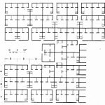
The first drawings communicate a strictly hierarchical structure in the plan: a number of small residential units are combined to form a community and a number of communities together form a neighbourhood.
A housing unit is formed by a group of 90 dwellings which contains different types capable of meeting the needs of all age groups: two stories bars, and three lower blocks. These elements are grouped together to form five neighborhood units separated by green belts hosting the schools. One lane crosses the whole neighborhood from east to west to delineate two units in the north side and three in the south. The main lane also contains all the collective equipment belonging to the operation as a whole.

The project is first exhibited at CIAM 7 in Bergamo in 1949, its first version being criticised for being too rigid and repetitive, in line with projects exhibited through the CIAMs of the pre-war period.
Learning from the critics received during CIAM 7 and stimulated by the thematic of the CIAM 8 (“The Core”), Bakema resumed the work by focusing on the presence of ”cores” at all the scales (for the full plan, in the neighborhood units).
Through the development of the second version, the idea emerges of a “Visual group”: the neighborhood units that can be understood at the visual level.
The plans of the second version show an attempt to organize a large number of housing units (6,300) using a series of interrelated spatial associations each provided with specific characteristics: housing, the cluster, the neighborhood, and the city. The district configures four neighbourhoods around a pedestrian square. The fundamental unit chosen for these neighborhoods was the wooneenheid (or cluster): this form of spatial organization implements a physical and social connection between every single home and the neighborhood considered as a whole. Each cluster consists of a mix of buildings that respond to different categories of residents, couples, families, singles, senior citizens. Shops are located in the central area of the neighborhood, but also spread over each cluster. This social diversity is reflected in the spatial arrangement of freestanding blocks of different heights surrounding a communal green space. Different kinds of green spaces and common activities, like children playgrounds and small shacks for garden utilities are also included.
 Pendrecht-Alexanderpolder Grid, a selection of the grid presented at CIAM X


Leave a Reply