SOCKS

An online magazine of Art, Architecture, Media, Culture, Sounds, Territories, Technology)

  • Media
  • Art
  • Architecture
  • Culture
  • Sounds
  • Territories
  • Visual Atlas

Abstract Layers of Territory: Maps by David Lemm

February 3, 2019 by Mariabruna Fabrizi Leave a Comment

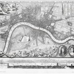
David Lemm is a visual artist and designer based in Edinburgh, Scotland. His production ranges widely from illustrations to collages, multi-media projects, prints, and installations, but all of his works share a consistent interest for synthesis and abstraction. A recurring theme in Lemm’s research is the translation of elements of the landscape, natural or urban, in the form of symbols and shapes recreating a visual narrative. This approach leads his personal take on the subject of cartography, in which the construction of maps becomes a way to talk about memory, physical and mental structures, and imagination.

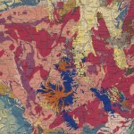
Mapping Eigg is a project which resulted from a residency at Sweeney’s Bothy on the Isle of Eigg as part of the Life Off the Grid project with Edinburgh University and The Bothy Project. David Lemm took his inspiration from the story of an infamous map lost on the island, to develop a series of experimental maps which translate spatial and human relationships on the site emerged through conversations with residents, journeys, reflections.

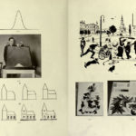
Lemm subsequently developed this method through workshops with school groups at various locations.

Another example of Lemm’s approach is the work Landshapes, in which a series of prints maps the journey up the Sgurr Alasdair, the highest peak on Skye. This time, the design describes the views encountered by the artist and translates them in shapes which move between the figurative and the abstract. The work was commission by ATLAS Arts to create a limited edition artwork in the form of postcards.

All images © David Lemm

Related Posts

  • The Territory as an Abstract Cartography

    Waiting to find some time to write a more extensive post, we leave you with…

  • 250mb of old maps of South London

    Maps dating back to the 16th century, free for downloading. Here. Londini Angliae Regni Metropolis…

  • David Katz's Psychological Atlas (1948)

    David Katz's Psychological Atlas (1948), is a collection of drawings, photographs, diagrams, and charts used by…

  • The way things go... David Weiss (1946-2012)

    Yesterday, one half of our favorite artists' duo has died of cancer. We'd like to…

  • David Knight's Making Planning Popular - A Manifesto

    A "growing database of arcane, marginalized, or forgotten planning practices" by David Knight, Making Planning…

Leave a Reply

Your email address will not be published. Required fields are marked *

  • Instagram
  • Twitter
  • Facebook
  • Tumblr

Socks is a non-linear journey through distant territories of human imagination.

About | Visual Atlas | Topics

We are Mariabruna Fabrizi and Fosco Lucarelli from Microcities. Ask us anything

  • Instagram
  • Twitter
  • Facebook
  • Tumblr


SOCKS is a project by Fosco Lucarelli and Mariabruna Fabrizi of MICROCITIES, Architecture Cityscape, Landscape.
Except where otherwise noted, the content on this site is licensed under a Creative Commons Attribution-ShareAlike 3.0 license.
Whenever possible we try to attribute content (images, videos, and quotes) to their creators and original sources. Please feel free to write us if you notice misattributions or wish something to be removed.
SOCKS is powered by WordPress.